|
By SurreyJohn - Monday, November 6, 2006
|
|
When linking to a place, it would be nice to add a title, description, some photos, and even a map. A place could be the old family house, a church where someone got married, or the village or parish on a census. Being able to add a description and some historic photos would be very nice. Also, for places, it would be great if we could hyperlink to a Google map, or some other such map. In the UK, we would use www.streetmap.co.uk. Any hyperlink would meet the basic requirement, but use the Latitude/Longitude would be a real smart move!
|
|
By V.L.o - Tuesday, November 7, 2006
|
|
It's all more or less possible with beta versions of Genopro... BTW. Which version of genopro are you using?
|
|
By SurreyJohn - Tuesday, November 7, 2006
|
|
I was using the Beta from last week. I'm on version 2b19f from today.
|
|
By V.L.o - Wednesday, November 8, 2006
|
SurreyJohn (11/6/2006)
When linking to a place, it would be nice to add a title, description, some photos, and even a map. A place could be the old family house, a church where someone got married, or the village or parish on a census. Being able to add a description and some historic photos would be very nice. Also, for places, it would be great if we could hyperlink to a Google map, or some other such map. In the UK, we would use www.streetmap.co.uk. Any hyperlink would meet the basic requirement, but use the Latitude/Longitude would be a real smart move! So, have you seen all the options and description details in places... Descriptions etc.... even Latitude and Longitude. Only thing which might be added is option in report generator to use coordinates fields to create a hyperlink to Worldwind or Google earth ... or Streetmap if it's possible...
|
|
By Poolzone - Wednesday, November 8, 2006
|
When linking to a place, it would be nice to add a title, description, some photos, and even a map. I am looking forward to using the ability to map places. Right clicking on a Place within the dialogue allows the insertion of latitude and longitude. I have a small sample of it's use at http://familytrees.genopro.com/poolzone/test3/ The integration is not yet dynamic, but hopefully will be able to be in the future. These maps could hopefully be inserted within the report generator via a map icon in the future.
|
|
By maru-san - Wednesday, November 8, 2006
|
poolzone (11/9/2006)
When linking to a place, it would be nice to add a title, description, some photos, and even a map.
The integration is not yet dynamic, but hopefully will be able to be in the future. These maps could hopefully be inserted within the report generator via a map icon in the future.
May be a link using software from http://thinkgeo.com will do the trick.
|
|
By Poolzone - Wednesday, November 8, 2006
|
|
May be a link using software from http://thinkgeo.com will do the trick. Thank you maru-san. I also have an example under http://familytrees.genopro.com/poolzone/test2/ using Google Maps and if I get enough time should be able to integrate coordinates using API and then insert the map on demand given any Place reference within the report. However I must balance available time against the value of the outcome. I will further investigate "thinkgeo" as you suggest.
|
|
By maru-san - Thursday, November 9, 2006
|
Found another page with info about building something you may have in mind:
http://www.allthegoodness.com/projects/map/index.php
Good Luck.
|
|
By SurreyJohn - Thursday, November 9, 2006
|
|
When I list placenams on the report, what I get it very minimal – just a list of who lived there  I’m very new to this version so maybe a little naïve, but I expected better. Having taken the trouble to add latitude and longitude and comments (to Birkenhead), I was looking forward to see a map and the information reported, but nothing! I have now discovered how to add pictures, and by use of the custom tags I can also add other detail. However, a dynamic link to a mapping web site is still sadly beyond me reach. I’m very new to this version so maybe a little naïve, but I expected better. Having taken the trouble to add latitude and longitude and comments (to Birkenhead), I was looking forward to see a map and the information reported, but nothing! I have now discovered how to add pictures, and by use of the custom tags I can also add other detail. However, a dynamic link to a mapping web site is still sadly beyond me reach. I have managed to add maps as pictures, but not as good as http://www.google.com/maps http://homepage.ntlworld.com/johnmather/Family/Mather/default.htm?page=toc_places.htm How can I get the entered information repored better?. 
|
|
By Poolzone - Thursday, November 9, 2006
|
|
However, a dynamic link to a mapping web site is still sadly beyond me reach. At this stage Genopro have thoughtfully included the fields longitude and latitude for inclusion. They were placed there as a request from a Forum member. The development of the Report Generator to output the results from this information will surely follow. In the following link click on the words above the map....LAUNCESTON MAP. If there is enough request for this it is a rough example of what we should be able to achieve on all Place names in the future. http://familytrees.genopro.com/poolzone/test/ Note: I mean a very ROUGH example.
|
|
By jcmorin - Thursday, November 9, 2006
|
|
I have moved this thread into the report generator category. Poolzone continues to push the limit of the report generator capability, this time with geo mapping. We do encourage people to create new skins and modify the current ones. Over time many skins will be created and may be added to GenoPro with their permission. Remember that the English narrative report has been created by Ron... from scratch.
|
|
By maru-san - Saturday, November 11, 2006
|
Poolzone, you are doing great with your map. Actually I was thinking the same way, but then my question was, what will happen to the loading of the report, once you have the google map installed for 200 places or more.
And another question: wouldn`t it be better to have a central place for the map, where you can look up all places at once at a glance, where the location is already defined by the available latitude and longitude of all places.
Will follow your search for best results.
|
|
By Poolzone - Saturday, November 11, 2006
|
|
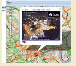
what will happen to the loading of the report I believe that the best place to display the map is in the 'popup' provided by referenceing to the Place from the individual narrative. This way it can be referenced specifically to the place, whether place of birth, death marriage etcetera and the map will only be loaded one at a time as requested. Using Google or Yahoo Maps allows us to have a fully interactive map at a zoom factor that suits the end user. For this reason, we will never have maps pre-loaded, and we can use the latitude and longitude data entered in Genopro as you have suggested. In my latest example at http://familytrees.genopro.com/poolzone/test/ you will see by looking at the individual page for member 2B, and then accessing his place of birth, the Google Map is displayed (currently with location text box above which can be ignored). If you look below the map, the co-ordinates are displayed from the Genopro file. I do not have enough programming knowledge to bring these global variables from VBscript that creates the reference to lonitude and latitude from Genopro and prints it below the map, to be used as a value within the Javascript. That is all that stops us from using the current report writer to generate a location map for any given Place entered in Genopro for which we have entered the co-ordinates. I believe that the solution will be straight forward for a programmer of Javascript or else I'll find it in due course.
|
|
By IainTait - Sunday, November 12, 2006
|
|
This looks like a very useful idea that I hadn't really concidered before, thinking it too difficult for me. I look forward to it's developement with interest as I might want to include it in my tree one day when it is perfected by the "experts" 
|
|
By GenoProSupport - Sunday, November 12, 2006
|
|
This is amazing! I never thought the report generator could do so much.
|
|
By genome - Sunday, November 12, 2006
|
|
I'll look into the possibility of integrating maps with places in the Narrative Report along the lines that poolzone has suggested.
|
|
By Poolzone - Sunday, November 12, 2006
|
|
Thank you Ron, I would be pleased if you would investigate the incorporation of this option within your report skin. I know you may not need it , but I would be pleased to send a copy of the "Place.htm" skin I have used to generate the sample. The only other changes were to declare and set the value of the variables "StrHtmlLati" and "StrHtmlLong" in Util.vbs.
|
|
By genome - Monday, November 13, 2006
|
|
I have coded a prototype skin that will display a Google map of each place with latitude & longitude set. It also uses Google Maps API 'geocoder' to attempt to obtain a grid reference for place names where no grid reference is present. If successful the map is displayed. I have posted an example report based on the Harry Potter familiy tree here http://familytrees.genopro.com/Ron/HarryPotter/default.htm. Most of the places in this report are in the Education narratives, so it is probably easier to use the places index and work back form the place reference to the education/occupation to see it working. The 'geocoder' does not seem to be as good as the standard Google Maps location search unfortunately. This is just a simple use at present. Next I am looking at producing a Google Map with all the tree's places on it. I hope to use place category to control which markers are displayed at each zoom level using the Google Maps API 'marker manager'. Let me know of any other wish-lists for mapping of GenoPro data. Update: just added double-click 'center and zoom in' and double right-click 'zoom-out' to make map navigation easier.
|
|
By Poolzone - Monday, November 13, 2006
|
|
Excellent work Ron, beyond my expectations in this short time. You are now responsible for Genopro members everywhere editing their files to include latitude and longitude on all Places. But the results will be worth it. Thanks.
|
|
By maru-san - Monday, November 13, 2006
|
Woh, this was faster than expected, and good work.
Ron, can you try with a picture for that place to the right? Can the googlemap kept placed right underneath of the narrative phrase, but still keeping the picture to the right of the googlemap? Have resized pictures to 170x170, so the googlemap may be less than 500 in width, may be 450 or similar. Or can you make the size flexible in size, so it will always fit in that place as described above?
|
|
By V.L.o - Monday, November 13, 2006
|
|
Impressive, ... it's pushing I know, but is it possible to set some zoom settings on (google)map?
|
|
By Poolzone - Monday, November 13, 2006
|
|
can you try with a picture for that place to the right The inclusion of Geomapping via Google Maps allows many new methods of displaying data such as ....
 and we could even include a directory of thumbnails on the placeholder. Ron's inclusion of the javascript to use Google Maps will allow a vast array of individually customised reports. There is a nice map here mapping photos taken at different locations...http://www.panoramio.com/
|
|
By IainTait - Monday, November 13, 2006
|
I thought we had covered all the possibilities until I saw this new developement.  The idea of adding photos to the text box on the map is superb and I will be strongly tempted to use this when it is completed by our Guru Ron.  Obviously I would ask for a little help in finding the right way of entering the place coordinated. 
|
|
By Poolzone - Monday, November 13, 2006
|
|
Please refer to the following to include your geomap references Go to a Place in the Genopro file dialog such as Right clicking on a member of the tree and selecting.... 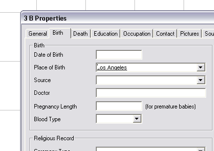
Then, Right click on the Place and the following screen will be displayed 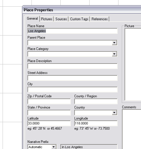
Add the geomap coordinates and enjoy the enormous benefits of Ron's report skin.
|
|
By IainTait - Tuesday, November 14, 2006
|
|
poolzone (11/14/2006)
Add the geomap coordinates and enjoy the enormous benefits of Ron's report skin.Thanks for the tip. Only one question now, where do I find the geomap coordinates ? 
|
|
By appleshaw - Tuesday, November 14, 2006
|
For the UK try http://www.streetmap.co.uk/ and put in a location. The coordinates are in small print at the bottom.
Michelin provide a similar service in France but I do not know if it includes coordinates.
|
|
By IainTait - Tuesday, November 14, 2006
|
appleshaw (11/14/2006)
For the UK try http://www.streetmap.co.uk/ and put in a location. The coordinates are in small print at the bottom. Michelin provide a similar service in France but I do not know if it includes coordinates. Thanks a lot for this, I have already found several of the places I need and I had found a few Australian ones on another site but it doesn't have a lot of choice, only the main cities.
|
|
By genome - Tuesday, November 14, 2006
|
If you have the address you may not need the latitude & longitude. The geocoder will find most - its just the UK where it seems at bit weak. My code will try and find the place cordinates for the map using the street, city, county etc. info in the Place object. If these are not present it will try the place name. If you add the postcode and set country to UK for UK places the postcode will be displayed as link to streetmap.co.uk.
Nearly ready to send a skin to Dan. Mapping will be turned off by default in Config.xml so if you want to try it you'll need a custom skin. Each use of Google Maps API needs an API key. The default one in the skin will work on http://familiytrees.genopro.com and on your local PC only. If you publish to another site you will need to get an API key for it from http://www.google.com/apis/maps and store it in Config.xml. This file will also hold default zoom level and map size. You will be able to tailor these values for selected Places using custom tags.
|
|
By IainTait - Tuesday, November 14, 2006
|
|
Hi Ron, I just made a test tree of my direct ancestors and had included some olace coordinates before generating a report after having created the new narrative report, but couldn't see any maps.  I'm obviously missing something mentioned elsewhere. I did however discover your pedigree chart which is superb. 
|
|
By genome - Tuesday, November 14, 2006
|
|
Ron (11/14/2006)
Nearly ready to send a skin to Dan. It's because I've not released the skin yet!
|
|
By SurreyJohn - Thursday, November 16, 2006
|
|
I see no maps !
|
|
By IainTait - Thursday, November 16, 2006
|
|
SurreyJohn (11/16/2006)
I see no maps !Ron (11/14/2006)
Nearly ready to send a skin to Dan. It's because I've not released the skin yet!
|
|
|
By GenoProSupport - Thursday, November 16, 2006
|
|
A new update should be available in a few days. Beta 20 is under way...
|
|
By bogistad - Thursday, November 16, 2006
|
|
Coordinates for most countries can be obtained from http://www.heavens-above.com/countries.asp
|
|
By IainTait - Tuesday, November 21, 2006
|
|
I have been having fun adding photos to the genomaps so that they show up in the SVGs and also some map references and hope to update my tree before Christmas. I am just waiting for some photos from a cousin before doing so. I will need to personalize the skin for this and wonder when the last and diffinitive skin will be released, as I have done this several times now and each time a new Beta arrives I have to do it again. Can I do it now or will there be changes to the skin in the next Beta ?
|
|
By GenoProSupport - Tuesday, November 21, 2006
|
|
IainTait (11/21/2006)
I will need to personalize the skin for this and wonder when the last and diffinitive skin will be releasedIt is coming. Ron had done almost all the changes with the new tags. Here is a list of the modified tags. I will post a more official post about what tags have been changed from Beta 19 to Beta 20. - GenoMap.boundary_rect -> GenoMap.BoundaryRect
- Individual.position.boundary_rect -> Individual.position.BoundaryRect
- Individual.hyperlink_data_source -> Individual.IndividualInternalHyperlink
- Individual.FirstMiddle -> Individual.FirstAndMiddle
- Individual.FirstLast -> Individual.FirstAndLast
- Individual.Name.Full.Format -> Individual.Name.Format
- Individual.is_adopted -> Individual.IsAdopted
- Individual.pregnancy_length -> Individual.PregnancyLength
- Individual.Spouses -> Individual.Mates
- Family.Label -> Family.DisplayText
- Family.AgeAtWeddingHusband
- Family.AgeAtWeddingWife
- PedigreeLink.pedigree_link -> PedigreeLink.PedigreeLink
- EmotionalRelationship.emotional_link -> EmotionalRelationship.EmotionalLink
- EmotionalRelationship.individual1 -> EmotionalRelationship.Entity1
- EmotionalRelationship.individual2 -> EmotionalRelationship.Entity2
- EmotionalRelationship.individual1GenoMap -> EmotionalRelationship.Entity1GenoMap
- EmotionalRelationship.individual2GenoMap -> EmotionalRelationship.Entity2GenoMap
- Twin.twin_link -> Twin.TwinLink
- Shape.closed_figure -> Shape.IsClosed
- Picture.path.file_unique -> Picture.Path.FileUnique
- Picture.file_size -> Picture.FileSize
- Occupation.work_type -> Occupation.WorkType
- Occupation.Start.Date -> Occupation.DateStart
- Occupation.End.Date -> Occupation.DateEnd
- Education.Start.Date -> Education.DateStart
- Education.End.Date -> Education.DateEnd
- Contact.Start.Date -> Contact.DateStart
- Contact.End.Date -> Contact.DateEnd
- *.Dependents -> References
- *.Dependents.Count -> References.Count
I also changed the following enumerations: - PlaceCategory
- SourceMediaType
- EmotionalRelationships (removed the underscore to all fields, such as hostile_distant).
- Added 'Jealousy' to the emotional relationships
- Added 'Commitment Ceremony' to the union type
|
|
By IainTait - Tuesday, November 21, 2006
|
|
Thanks for the info, I take to mean that I had better wait for a few days before tackling my personalised skin ? Another question -I have added lots of new family branches since Easter and as I ended up with strange IDs I errased them all and created new ones. Will this create a problem with my update as most of the IDs will have changed ? PS. I've just been emailed by another of my collaborators who is signing up tonight to buy GenoPro. I have lost count of the number who have done this since I started mentioning your software when contacted through Genes Reunited or Ancestry. The more the merrier
|
|
By GenoProSupport - Tuesday, November 21, 2006
|
|
IainTait (11/21/2006)
Will this create a problem with my update as most of the IDs will have changed ?All your previous data, including IDs will be imported, as the renaming of tags only affects the report generator. All the previous tags are support to import the data, but they are no longer exported nor supported by the report generator.
|
|
By IainTait - Tuesday, November 21, 2006
|
|
I don't use Custom Tags but would like to know what happens to the old tree with the different IDs as I am worried about possible duplications or erroneous connections. As I only update a couple of times a year, I am always tempted to delete the old tree and upload the full new tree to avoid errors. Last time I noticed that I couldn't just delete the tree but the home folder went with it. My tree will pass from 1200 names to 19000 names !
|
|
By hjdl - Tuesday, November 28, 2006
|
|
The idea to link with a google map interfase was superb. I wait to the Beta 20 for this purpose, but i think this report generation version doesn't include this link.
|
|
By genome - Tuesday, November 28, 2006
|
|
Beta 20 has the Google Maps place link but it is not turned on by default. You will need to generate a custom skin and edit Config.xml to turn on this feature. Please read the notes in Config.xml, especially if you intend to publish to a web site other than familytrees.genopro.com. If there are not too many problems with this beta trial of the Google Maps perhaps it will be turned on by default.
|
|
By IainTait - Tuesday, November 28, 2006
|
|
I tried making a report with the Google map switched on and saw the result for Kew, Melbourne, Australia which is very good, but no other place in the UK or elsewhere could show up, not even places like Liverpool, Glasgow or Hobart, Tasmania. I had tried first with the co-ordinates I had entered as found on the sites recommended, but the places didn't show up so I removed them in my test tree with no effect; only Melbourne shows up. Is this normal or am I missing something ?
|
|
By Poolzone - Tuesday, November 28, 2006
|
IainTait (11/28/2006)
I tried making a report with the Google map switched on and saw the result for Kew, Melbourne, Australia which is very good, but no other place in the UK or elsewhere could show up, not even places like Liverpool, Glasgow or Hobart, Tasmania. I had tried first with the co-ordinates I had entered as found on the sites recommended, but the places didn't show up so I removed them in my test tree with no effect; only Melbourne shows up. Is this normal or am I missing something ? The Google Maps API first uses the co-ordinates installed in Genopro for each Place, in the metric form e.g. -33.123456 and 140.123456 . If no co-ordinates are supplied then the system will try to search using a very limited geomapping function, which works ok in most of the World, except UK. Uk addresses are not currently included. If the co-ordinates are entered via Genopro then the map will locate and display those co-ordinates. Please note that Hobart, Tasmania is not correct for geomapping. It should be entered as Hobart,Australia or Hobart, Tasmania, Australia. The country is neceesary, not necessarily the State, except to overcome amiguities.
|
|
By IainTait - Tuesday, November 28, 2006
|
|
Thanks for the tips, I had entered the coordinates in the form N and W and not the form you mentioned. I will try again. Update:- I gave it a try with the correct type of coordinates and the result was very interesting !
|
|
By hjdl - Wednesday, November 29, 2006
|
|
Good job Ron !! Its a great funcionality. I change the default value in the config.xml ==> GoogleMaps="Y" and its work very good. With decimal coordinates there is no problem. With USA address neither. I found a trouble with degrees because it doesn't recognize this lat: 25º 35' N ; lon 35º 15' W (may be the especial character º, blankspaces or anything else) Congratulations !!
|
|
By bogistad - Wednesday, November 29, 2006
|
|
Ron, congratulations on a terrific feature. Well done! I have a friend who was so impressed that he is now thinking of buying GenoPro. He had one question, is there any way of surpressing the text box from automatically popping up? I would think this was a purely GoogleMaps feature.
|
|
By genome - Tuesday, December 5, 2006
|
|
He had one question, is there any way of surpressing the text box from automatically popping up? I would think this was a purely GoogleMaps feature. You can prevent the information bubble from appearing by removing the lines marker.openInfoWindowHtml(strPlace);
|
and
marker.openInfoWindowHtml(place.address + '<br>' +
'<b>Country code:</b> ' + place.AddressDetails.Country.CountryNameCode + '<br>' +
'<g>Grid Reference:</b> ' + place.Point.coordinates[1] + '/' + place.Point.coordinates[0]);
|
towards the end of script.js in a custom skin.
|
|
By bogistad - Tuesday, December 5, 2006
|
|
Ron, thank you. That worked fine.
|
|
By powery - Wednesday, November 28, 2012
|
Is it possible to add values 'village part' and 'city part' to the Place Category in Place Properties?
Thanks
|