|
By powery - Monday, October 13, 2014
|
Hello,
on the Overview Map of all geocoded places is displayed only mark with maximal ID place for places with same latitude and longitude. 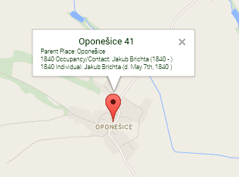 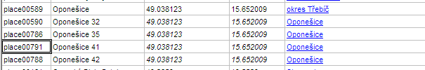 I have latest Narrative Report. Is it possible to correct it? Thanks
|
|
By genome - Monday, October 13, 2014
|
This code could be a solution Overlapping Marker Spiderfier = I'll look into it. I have tested this and it appears to work fine. I will include it in the next version. However I have various other enhancements in the pipeline so could be a few weeks away.
|
|
By powery - Tuesday, October 14, 2014
|
|
It works for you? All occupation/contacts and individuals for all places on the same coordinates are in the same bubble?
|
|
By genome - Tuesday, October 14, 2014
|
Perhaps I did not explain well. I have modified a test version of the Narrative Report to add Overlapping Marker Spiderfier script and now overlapping markers can be expanded. A demo by the author of of OMS is here. It will be available in the Narrative Report at a later date.
The information is not combined into one marker. Currently the markers are all on top of one another and so only the top one can be clicked on. The OMS script causes the overlapping markers to be spread out so that they can be clicked on individually.
|
|
By powery - Tuesday, October 14, 2014
|
|
OK. Thanks.
|