GenoPro Home
GenoPro Home  |  Get Started With My Genealogy Tree  |  Buy  |  Login  |  Privacy  |  Search  |  Site Map
 

GenoPro Support Forum


Author Can you enhance the controls available, and maybe make it possible to have maps with markers for all the places that a family have lived at ?
Posted Saturday, June 13, 2009 - Post #24195
Junior Member

Junior MemberJunior MemberJunior MemberJunior MemberJunior MemberJunior MemberJunior MemberJunior MemberJunior Member

Customers
GenoPro version: 2.0.1.4

Last Login: Tuesday, December 8, 2009
Posts: 10, Visits: 62
It would be really great if the google map features were extended a little.

It would be good to have the full map controls that we see on google itself, with the ability to see the terrain map, zoom from the mouse wheel, etc . I think these are the updates that would be required to the function showGoogleMap


    gMap.enableScrollWheelZoom();
    gMap.addControl(new GLargeMapControl3D());
    gMap.addControl(new GOverviewMapControl());
    gMap.addControl(new GHierarchicalMapTypeControl());
    gMap.addMapType(G_PHYSICAL_MAP); 

I'd really like to have the google map on the Individual's page - showing markers for all the entries in the whereabouts list (where the location can be determined). Below is a mock up of the what I have in mind. 

The icing on the cake would be to have a page per surname with a map of all the locations associated with that family name.

I know GenoPro is used for lots of different purposes, but those of us using it for to record the results of our family history research one of the very facinating aspects is understanding where various branches of our families came from, and how they've moved around over the years.

btw... The web generator is fantastic - it's made my research very very accessible to the rest of my family !

Posted Monday, June 22, 2009 - Post #24236
Junior Member

Junior MemberJunior MemberJunior MemberJunior MemberJunior MemberJunior MemberJunior MemberJunior MemberJunior Member

Customers
GenoPro version: 2.0.1.4

Last Login: Tuesday, December 8, 2009
Posts: 10, Visits: 62
I wanted to share the progress I've made on producing a map representing the movement of families. Here is a screenshot, then I'll go into a bit of detail about how it was generated etc...
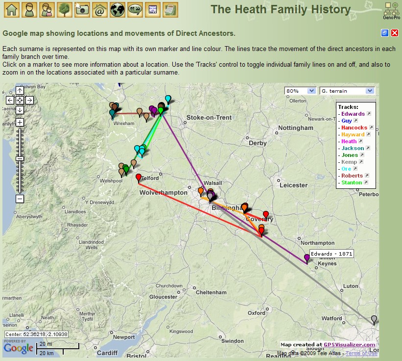
I've found a website which can generate the maps, which can then be saved and loaded as an iframe in the Narrative report : http://www.gpsvisualizer.com/map_input?form=google

The website is aimed at people uploading their data from their gps devices (runners, cyclists, hot air balloonists, etc), so in order to get it to draw lines, you've got to enter some spurious time/speed info.

The website allows you to upload comma separated files containing the gps and marker data.  There is great documentation on the site, so I won't reproduce it here, but here is a portion of the csv files I uploaded to create the above map.

The file to create the markers is simple :

name,colour,description,lat,lon
"Roberts  - 1851, 61",brown,"Gresford under the Hill, Denbighshire, Wales",53.087555,-2.966352
"Roberts  - 1763, 1804, 32, 61, 65, 71",brown,"Gresford, Denbighshire, Wales",53.087014,-2.967682
"Roberts  - 1881",brown,"Station Street (no 40), Monks Coppenhall, Crewe, Cheshire",53.089823,-2.434545
"Roberts  - 1891",brown,"Christ Church, Crewe, Cheshire",53.096847,-2.440038
"Roberts  - 1897",brown,"Carlisle Street (no 4), Monks Coppenhall, Crewe, Cheshire",53.086911,-2.449458
"Roberts  - 1901",brown,"Walthall Street (no 239), Monks Coppenhall, Crewe, Cheshire",53.088934,-2.445638
"Stanton - 1768", 1806, 41",lime,"Stanton upon Hine Heath, Shropshire",52.811634,-2.641997
"Stanton  - 1881",lime,"Bella Terrace, Shavington, Cheshire",53.062856,-2.450337

The file to create the lines (a track in the terminology of gpsvisulizer) is a little less obvious :

type,trackpoint,name,colour,lat,lon,speed,time,BOT,EOD
t,1,Roberts,brown,53.087555,-2.966352,1,12:00:00,1,
t,2,,,53.087014,-2.967682,1,13:00:00,,
t,3,,,53.089823,-2.434545,1,14:00:00,,
t,4,,,53.096847,-2.440038,1,15:00:00,,
t,5,,,53.086911,-2.449458,1,16:00:00,,
t,6,,,53.088934,-2.445638,1,17:00:00,,1
t,1,Stanton,lime,52.811634,-2.641997,1,12:00:00,1,
t,2,,,53.062856,-2.450337,1,13:00:00,,1

The first column tells gpsvisulizer it is a "track", the second is the sequential number of the track point. Then you have the track name and colour (which only have to be set for the first point on the track).
Lat and Lon are obvious. The next two fields are spurious & arbitrary from our perspective, but seem to be necessary to get the "track" to draw - they're a fictional speed and time at each track point, I chose to increment the time by one hour for each track point.
The last two fields stand for "Beginning Of Track" and "End of Track" - use value of 1 if it is. It's just a way of having several "tracks" in one file.

Once you've got gpsvisulizer to create the map it gives you a link for saving it - (basically it opens the map on it's own, so you can right click and save the source code locally).

In terms of getting it to load in the Report, I've followed the advice of the gpsvisulizer site, and used an iframe.

<iframe src="my_map.html" width="600" height="400" marginwidth="0" marginheight="0" scrolling="no" frameborder="0">
  <a href="my_map.html">Click here for the map</a>
</iframe>

As for getting the data out of GenoPro and munged into the right format - well that was a manual process copying the data from the Individuals, Places and Contacts tables into excel, with some judicious vlookups to bring the surnames, dates, places, and lat/lon information together on one sheet. (I can't code for toffee, but I'm sweet with Excel.)

It's been a fair amount of work, not least of which was researching the lat/lon for all the locations in my family tree (600+, with many streets which no longer exist - so some sleuthing was required there).

Hope this is of some use to others out there.

Posted Tuesday, June 23, 2009 - Post #24242
Legendary Master

Legendary MasterLegendary MasterLegendary MasterLegendary MasterLegendary MasterLegendary MasterLegendary MasterLegendary MasterLegendary Master

Administrators
Customers
Important Contributors
FamilyTrees.GenoPro.com
GenoPro version: 3.1.0.1

Last Login: Yesterday @ 8:38 PM
Posts: 3,418, Visits: 26,393
Yes that looks impressive. Thanks also for your other suggestions on improving the Google Maps aspects of the Narrative Report. It should be possible to achieve this using the Google Maps API directly in the Report rather than use of a separate process.

I'm a little reluctant to make many more changes to the Report right now. It has been showing stress from its organic growth for sometime and really should be rebuilt from the bottom up.

I have been lookiing around at the various javascript framework packages available but as yet not found one quite to my liking.


'lego audio video erro ergo disco' or "I read, I listen, I watch, I make mistakes, therefore I learn"
Posted Wednesday, June 24, 2009 - Post #24243
Junior Member

Junior MemberJunior MemberJunior MemberJunior MemberJunior MemberJunior MemberJunior MemberJunior MemberJunior Member

Customers
GenoPro version: 2.0.1.4

Last Login: Tuesday, December 8, 2009
Posts: 10, Visits: 62
No problem - I quite understand. I'm aiming to get some memory sticks out the door containing Narrative Reports of the family trees I've done for various folks as soon as possible, so I'm busy "tweaking" the current release candidate to suit.

While I'm a systems administrator and fairly competant with computers, I'm a complete deadhead when it comes to code, so no major changes. I've gotten rid of the A - Z top level list element on each of the Indexes. For the Sources and Places Indexes I've modified the code so that a particular entry only comes up once - under it's parent source. For instance "Nantwich, Cheshire" now only appears under it's parent "Cheshire", rather than also appearing lower down the list with the N's. The advantage is that it makes the list easier view (and shorter), the disadvantage is if someone particularly wants to look at Nantwich, but doesn't know it's in Cheshire.... but I can live with that ;-) Oh, and I've also added some classes to body in the style.css to enable a different look for each of the frame types - indexes, main windows, popups, and the little frame along the top.  

Having done a fair amount of trawling of the support forums - I gather the report generator and the reports are all your work. Impressive!


Similar Topics

Click to view RSS...
Expand / Collapse

Reading This Topic

Expand / Collapse
Active: 3 - 1 guest, 1 member, 0 anonymous.
Refresh